Innovation at the Islands: Nearshore Reef Construction to Control Erosion at Gibraltar Point
September 6, 2018
Since spring 2018, Toronto and Region Conservation Authority’s (TRCA) Environmental Monitoring and Data Management team, in partnership with Fisheries and Oceans Canada, has been monitoring fish communities and turbidity conditions in support of the Gibraltar Point Erosion Control Project at the Toronto Islands. This data will determine baseline environmental conditions before construction begins on the innovative nearshore fish reef, designed to halt shoreline erosion at the site while also providing habitat for fish foraging and spawning.
 A severe storm event in February 2004 caused significant damage to an existing washroom building and associated infrastructure, prompting the City of Toronto to request the assistance of the Toronto and Region Conservation Authority (TRCA) to develop a long-term solution to address the known shoreline erosion issue at Gibraltar Point. TRCA initiated the Gibraltar Point Erosion Control Project under the Class Environmental Assessment for Remedial Flood and Erosion Control Projects (2002); the approved process for projects of this type carried out by Conservation Authorities.
 This photo depicts a conceptualized drawing of the proposed nearshore reef at Gibraltar Point by Baird Consulting, Inc. The proposed submerged reef will incorporate small, medium and large particles, designed to ultimately protect the Gibraltar Point shoreline from smaller, more frequent southwesterly waves and the larger, more destructive southeasterly waves. The interstitial spaces between the rocks should provide both foraging and spawning opportunities for lake fish species.
This novel approach to erosion control is the design of coastal engineers from Baird, Inc. with input from Aquatic Habitat Toronto is a multi-agency cooperative dedicated to helping direct and design the aquatic habitat compensation for waterfront development projects so they satisfy the Toronto Waterfront Aquatic Habitat Restoration Strategy (TWAHRS). TWAHRS was developed in 2004 to ensure that the revitalization of the waterfront incorporates improvements to aquatic habitats as an integral part of creating a more livable and sustainable waterfront. The overall goal of TWARHS is to maximize the potential ecological integrity of the Toronto waterfront. The creation of the nearshore reef follows the TWAHRS targets for open coast habitat. This Project also builds upon considerable work along the Toronto regional waterfront over the last few decades to restoring natural habitat and improving water quality in support of the Toronto and Region Remedial Action Plan (RAP).
The nearshore reef planned for Gibraltar Point is a great example of how aquatic habitat features can be included in an engineered erosion control design. The proposed reef at the Gibraltar Point location will incorporate different stone sizes. The placement of cobble will create sheltered interstitial spaces for invertebrates and small fish while boulders will provide cover and protection (Kavanagh and Hoggarth 2016). The habitat requirements for a sample of fishes found along the Toronto waterfront shows that boulder and cobble habitats are highly desirable habitats for a variety of life stages (Lane et al. 1996) of coolwater and coldwater fishes that could potentially utilize the created reef.
The innovation lies not only in the design, but it leads to advances in TRCA’s expertise. For example, the Project will provide a unique opportunity for TRCA to evaluate the succession of how well the freshwater nearshore reef habitat functions for native lake fish, while also enhancing the organization’s knowledge surrounding aquatic habitat design. “This Project pushes the boundaries on traditional erosional protection design,” says Rick Portiss, Senior Manager, Environmental Monitoring and Data Management, TRCA. “TRCA is excited to be involved at the ground-level of this project, as it provides us with the unique opportunity to monitor lake fish communities using different survey techniques during the pre-construction, construction, and post-construction phases of the project. The knowledge gained through this active long-term monitoring will be invaluable to building knowledge of Toronto area fisheries and contribute to the bigger picture of fisheries in Lake Ontario and the Great Lakes. We are pleased to work alongside Fisheries and Oceans Canada collecting important environmental monitoring data for this precedent-setting Project.”
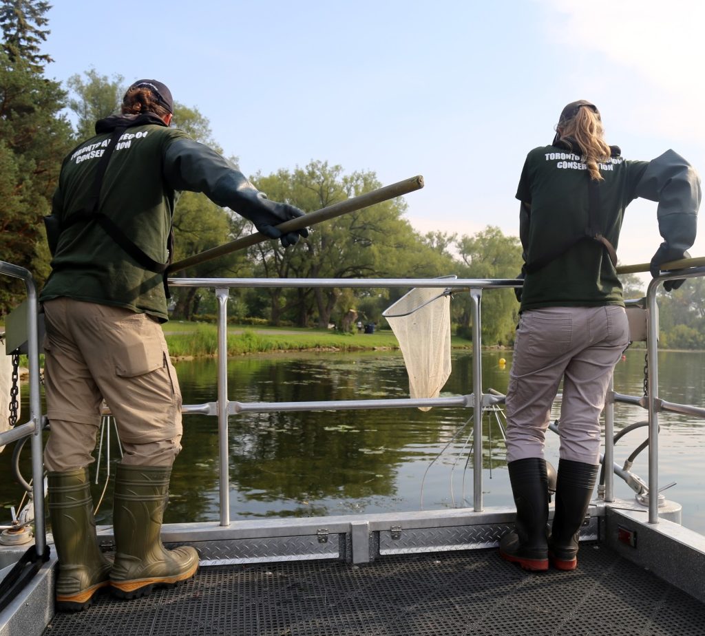
 TRCA’s Environmental Monitoring and Data Management team conducting nearshore fisheries surveys using seine nets. This is one of the survey techniques that will be used to collect data on the submerged nearshore reef planned for Gibraltar Point.
This table showcases the fish species recorded near Gibraltar Point since the inception of TRCA’s fisheries waterfront monitoring program in 1989. The fish community represented in this table consists of mainly coldwater fish species.

Without this long-term solution to shoreline erosion processes, the unprotected land around Gibraltar Point would continue to be subject to significant erosion, putting places of culture, natural ecosystems (such as Environmentally Significant Area, an Area of Natural and Scientific Interest, and Provincially Significant Wetlands) and built infrastructure in jeopardy of complete loss. This Project seeks not only to protect the loss of the island, and risks to infrastructure, but also to ensure that sand transport remains in place to maintain existing beaches and sand dunes.
 The Gibraltar Point and the adjoining Hanlan’s Beach area represents the largest remaining continuous habitat on the Toronto Islands. This habitat is significant to both migrant and resident fauna. For example, the most dynamic dune system in the western part of Lake Ontario is represented within the project area. These dunes create a diversity of growing conditions that support one of the largest concentrations of rare plant species within the City of Toronto and the largest population of provincially rare bushy cinquefoil (Potentilla paradoxa) shown in the photo above. This dune system and its associated wetlands are recognized as a provincially significant wetland complex and a candidate provincial Life Science Area of Natural and Scientific Interest.
The Islands continue to be regarded as the jewel of Toronto; a priceless piece of Toronto’s natural and cultural history. Despite many changes to its landscape through the late 19th and 20th century, the area retains some of the most ecologically valuable habitats of the Greater Toronto Area. With the addition of the nearshore reef at Gibraltar Point and its continuous monitoring, we can ensure that this unique natural heritage area of Toronto and region will be conserved.
Through scientific data collection, TRCA’s Environmental Monitoring and Data Management team tell the stories about the changes affecting the natural areas and watercourses within our regions. For more information, please visit our webpage, follow us on Twitter, subscribe to our Monitoring Matters e-newsletter, or visit our YouTube playlist.