Now accepting BIDA (GIS) requests on the ITRM Service Desk
December 1, 2020
Business Intelligence and Data Analytics (BIDA) is retiring the Geomatics Request Database on Lotus Notes and joining the existing ITRM Service Desk. Now there is one platform for all your IT, Database, and GIS needs. This move provides an improved process for intake, tracking, and communication with TRCA staff.
The Geomatics Request Database will remain available for reference and until open requests are completed but will no longer be accepting new requests.
On the ITRM Service Desk you will now see a BIDA (GIS) Requests category.
Please review this document or the following information on how to submit BIDA (GIS) requests and reach out to any BIDA staff if you have questions.
————————————————–
ITRM Service Desk – How to Submit a BIDA Request
You can submit BIDA (GIS) requests through the existing ITRM Service Desk on the TRCA StaffHUB.
Clicking on the BIDA (GIS) Requests option displays all BIDA request categories:
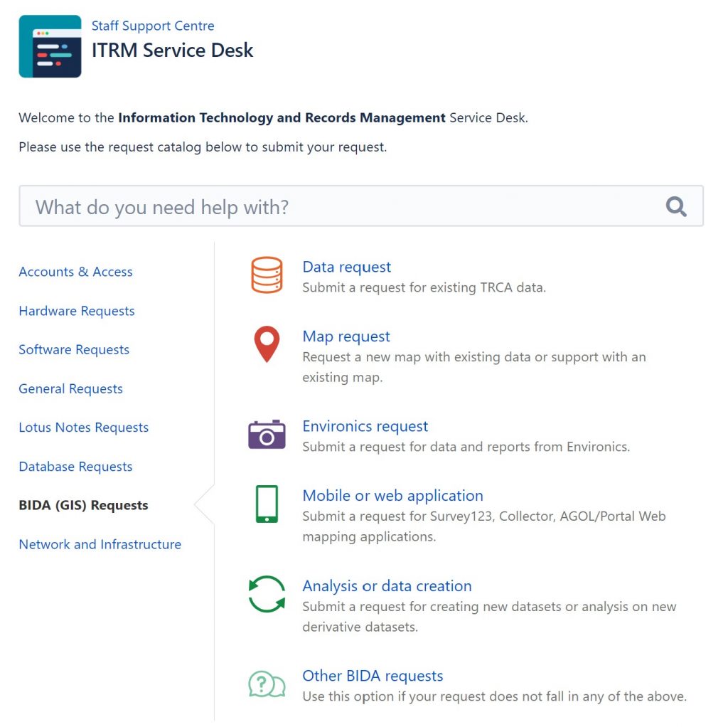
All categories require the Reporter (the staff submitting the request) to select their Division and if applicable their Business Unit. If you have attachments, include them at the top of each category. Please use OneDrive for attachments greater than 10 mb and include the OneDrive link with your request. Each request category has a spot where a direct account code can be provided and an ‘Additional Information’ box for any relevant request details. Below are additional details on the BIDA request categories:
- Data Requests: To process data requests and prepare a data sharing agreement, include the name of the project (Title), who the data is for (Data Audience), the needed TRCA data layers (Layers), the study area, how the data will be used, and who to contact. We can only provide TRCA data to external parties. For internal data requests choose ‘Other’ to include additional layers you may require. Use this category if you need existing LIDAR data (50 cm contours, 1m DEM, 1m Hillshade, raw LAS files). Note that we have a TRCA Open Data Portal where you will find readily available TRCA data.
- Map Requests: Choose this category if you would like a new map with existing data or support with an existing map. If you require a map with data that needs to be created, please choose the ‘Analysis or data creation’ category. For map requests, state the map objective and target audience, if you need digital or prints, map size, and number of prints if applicable.
- Environics/Mobile projects or web application/Analysis or data creation: Provide a summary, who the data audience will be and how the data or analysis will be used. A discussion can be had with BIDA staff to learn more about what application or analysis best suits your needs. Use the ‘Analysis or data creation’ category if you need LIDAR data that requires additional processing and include the study area shapefile needed for LIDAR requests and the account code– please see the LIDAR Data Requests HOW TO for additional information.
- Other BIDA Requests: Use this category for assistance if your request does not fall in any of the above categories. Please provide all relevant details.
If you need to request a new GIS software license, changes to your existing GIS software set-up, migrate a GIS license to a new computer, or de-authorize a GIS software license please use the ITRM ‘Software Requests’ category.
Once your request is submitted, you will receive an email confirmation receipt from the ITRM service desk with your request details. If you have forgotten to include something, you can reply to this email and include more information.
The assigned BIDA agent will contact you to discuss timelines and confirm deliverables. Once a timeline has been established, you will be able to track communications with BIDA staff and the progress of your request.